
Trekking Mount Tavurvur: Papua New Guinea’s Active Stratovolcano Adventure
Mount Tavurvur, an active stratovolcano in Papua New Guinea’s New Britain, offers a thrilling moderate trek through dramatic volcanic landscapes. This guide covers its geology, hiking terrain, eruption history, safety tips, and trekking logistics for adventurous volcano enthusiasts.
Quick Volcano Snapshot
| Volcano type | Stratovolcano |
|---|---|
| Elevation | 688 meters |
| Location | New Britain, Papua New Guinea |
| Activity status | Active |
| Trekking difficulty | Moderate |
| Typical trek duration | 4 to 6 hours round trip |
| Altitude gain | Approximately 400 meters |
| Terrain type | Volcanic ash slopes, lava rock fields, tropical forest |
| Best season | May to October (dry season) |
| Temperature range | 15°C to 28°C |
| Permit requirement | Required |
The Experience of Hiking Mount Tavurvur
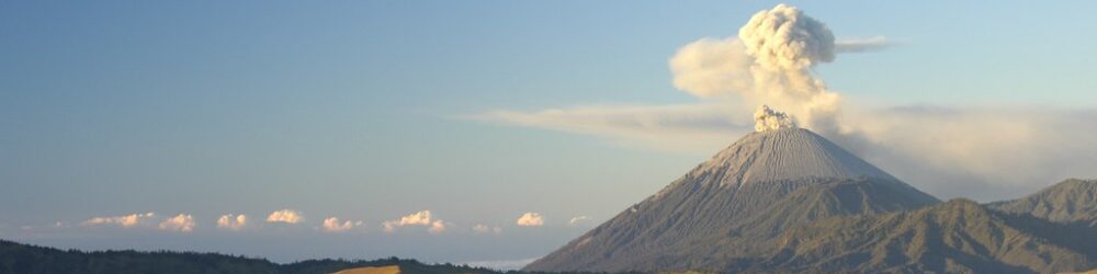
Approaching Mount Tavurvur reveals a stark landscape shaped by recent volcanic activity. Blackened lava flows and ash-covered slopes dominate the terrain, while a faint sulfur scent lingers in the air, signaling the volcano’s ongoing unrest. The ascent begins through lush tropical forests that gradually give way to barren volcanic ground. Hikers encounter a raw and powerful environment, culminating in the dramatic sight of the steaming crater rim. From this vantage point, swirling ash plumes and fumaroles create a dynamic and unforgettable panorama, offering a direct connection to Earth’s volcanic forces.
Mount Tavurvur: Geological Background
Mount Tavurvur is a prominent stratovolcano forming part of the Rabaul caldera complex on New Britain island. It consists of alternating layers of hardened lava, volcanic ash, and pyroclastic deposits built up over multiple eruptive episodes. The volcano is known for its frequent and sometimes violent eruptions, which produce towering ash plumes and lava flows that reshape the surrounding landscape. Sulfur-rich fumaroles and steam vents are common around the crater, depositing yellow sulfur crystals on the rocks. Due to its proximity to populated areas, Tavurvur is closely monitored by volcanologists, making it a significant site for both scientific study and adventurous trekking.
Terrain and Hiking Experience on Mount Tavurvur
The trek to Mount Tavurvur’s summit involves traversing varied terrain, starting with dense tropical forest trails that transition into volcanic ash slopes and rugged lava rock fields. The volcanic scree is loose and unstable, requiring careful footing and sturdy hiking boots. The trail steadily ascends, exposing hikers to open ridges where strong winds and fluctuating temperatures are common. Occasional scrambling over volcanic boulders adds to the challenge. The contrast between lush vegetation at lower elevations and the barren volcanic landscape higher up creates a unique and dynamic hiking experience.
What Makes the Mount Tavurvur Trek Unique
Mount Tavurvur stands out due to its active volcanic status and frequent eruptions, offering trekkers the rare opportunity to witness volcanic activity up close. The volcano’s dramatic ash plumes are visible from miles away, creating a striking spectacle. Its location within the Rabaul caldera adds geological significance and cultural context, as the nearby town of Rabaul has a rich history shaped by volcanic events. The trek combines the stark beauty of volcanic desert with the vibrant tropical island environment, while sulfurous fumaroles provide a sensory reminder of the Earth’s inner energy.
Summit and Crater Experience on Mount Tavurvur
Reaching the crater rim of Mount Tavurvur is a powerful sensory experience. The pungent smell of sulfur is strong near fumaroles and steam vents, and heat radiates from these active features. The crater often emits ash and volcanic gases, accompanied by occasional rumbling sounds from escaping pressure. From the summit, expansive views stretch across the Rabaul caldera, the surrounding ocean, and the lush island landscape. Observing active volcanic plumes against the sky is both humbling and exhilarating, providing a vivid connection to the planet’s dynamic geological processes.
Best Time to Trek Mount Tavurvur
The optimal time to trek Mount Tavurvur is during the dry season, from May to October, when trails are less slippery and weather conditions are more stable. The wet season brings heavy rains that can make volcanic ash slopes hazardous and increase the risk of landslides. Volcanic activity is continuously monitored, so trekkers must stay informed of current conditions and heed official warnings. Early morning or sunrise treks offer dramatic lighting and cooler temperatures but require preparation with headlamps and warm clothing.
Trekking Routes and Trail Options
The main trekking route begins near the outskirts of Rabaul town, ascending through tropical forest before entering volcanic terrain. The trail is approximately 4 kilometers one way, with an elevation gain of about 400 meters. Guided tours are strongly recommended for safety, navigation, and permit compliance. While self-guided trekking is possible, it requires local knowledge and experience with volcanic terrain. The round trip typically takes between 4 and 6 hours, allowing time for crater observation and photography.
Difficulty Assessment of the Mount Tavurvur Trek
Mount Tavurvur is classified as a moderate trek suitable for hikers with good fitness and sure-footedness. The loose volcanic ash and rocky terrain increase the challenge, though no technical climbing equipment is necessary. The volcano’s relatively low elevation reduces the risk of altitude sickness. Key difficulties include unstable footing on scree slopes, exposure to strong winds, and potential inhalation of volcanic gases. Due to these hazards, the trek is not recommended for beginners without experienced guides.
Essential Volcano Trekking Gear for Mount Tavurvur
Recommended gear includes sturdy hiking boots with strong grip, trekking poles for stability on loose scree, and gaiters to protect against fine volcanic ash. A windproof jacket is essential to guard against summit winds. Because of sulfur gases, carrying a lightweight respirator or gas mask is advisable. Sun protection such as a wide-brimmed hat, sunglasses, and sunscreen is critical due to minimal shade. Ample water and a headlamp are necessary for early starts or late returns.
Safety and Volcanic Hazards on Mount Tavurvur
Volcanic gases like sulfur dioxide can be harmful; avoid prolonged exposure near fumaroles. The crater edges may be unstable and prone to collapse, so caution is essential. Loose volcanic scree increases the risk of slips and falls. Although eruptions are monitored, sudden activity remains a danger. Always check updates from Papua New Guinea’s volcanic monitoring agencies and follow local guide instructions. Weather can change rapidly, so be prepared for wind, rain, and temperature fluctuations.
Permits, Guides, and Logistics for Mount Tavurvur Trekking
Permits are required to enter the Rabaul caldera and climb Mount Tavurvur. These are typically arranged through local tour operators or the Rabaul Volcano Observatory. Hiring a local guide is strongly recommended for safety, navigation, and cultural insight. Park entry fees apply, and seasonal closures may occur during periods of heightened volcanic activity. Logistics include transport from Rabaul town to the trailhead, often organized by tour companies, ensuring smooth access to the volcano.
Where to Stay Near Mount Tavurvur
Accommodation options are concentrated around Rabaul town, including guesthouses, lodges, and eco-resorts. Staying in Rabaul provides convenient access to the volcano trailhead and local guides. Some eco-lodges offer immersive experiences with views of Mount Tavurvur and cultural activities. Early morning departures for the trek are common, so lodging close to the trailhead is advantageous for convenience and safety.
