Mount Iwate Volcano Trekking Guide: Exploring Tohoku’s Highest Stratovolcano
Mount Iwate, the highest peak in Iwate Prefecture, Japan, offers an adventurous moderate trek through diverse volcanic landscapes. This guide covers geology, terrain, routes, safety, and local culture for an immersive volcano hiking experience in the Tohoku region.
Quick Volcano Snapshot
| Volcano type | Stratovolcano |
|---|---|
| Elevation | 2,038 meters (6,686 feet) |
| Location | Iwate Prefecture, Tohoku region, Japan |
| Activity status | Dormant |
| Trekking difficulty | Moderate |
| Typical trek duration | 8–10 hours round trip |
| Altitude gain | Approx. 1,400 meters |
| Terrain type | Volcanic ash slopes, loose scree, forest trails, lava flows |
| Best season | Late spring to early autumn (May to October) |
| Temperature range | 5°C to 20°C (41°F to 68°F) depending on season and altitude |
| Permit requirement | No permit required |
The Experience of Hiking Mount Iwate
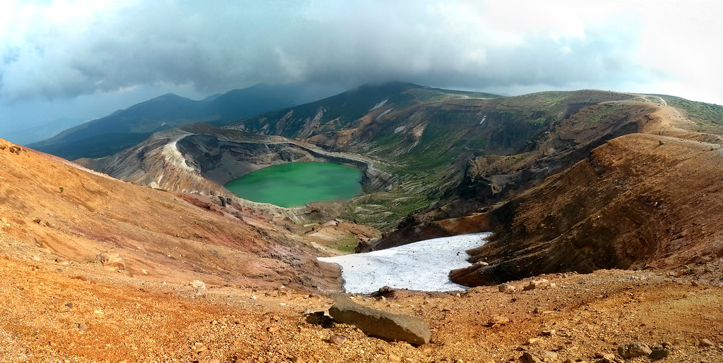
Approaching Mount Iwate, the landscape shifts dramatically from lush forests to stark volcanic slopes. The mountain’s symmetrical eastern cone rises above the Tohoku region, commanding views of alpine flora and rugged terrain. As you ascend, the contrast between dense beech and fir forests and the barren scree near the summit evokes the raw power of volcanic forces shaping this land. Reaching the crater rim, hikers are rewarded with panoramic vistas of the Towada-Hachimantai National Park and the serene crater lake below, a humbling encounter with geological time and nature’s grandeur.
![Mount Iwate volcano trek - Mt. Iwate / 岩手山(いわてさん)[9120 x 3380 = 30.9MP]](https://nadirview.com/wp-content/uploads/2026/03/01-mt-iwate-9120-x-3380-30-9mp.jpg)
Mount Iwate: Geological Background
Mount Iwate is a complex stratovolcano formed by two overlapping cones: the older western Nishi-Iwate and the younger, symmetrical eastern Higashi-Iwate, which forms the summit. The western cone collapsed to create a large caldera housing Lake Onawashiro. The volcano’s last major eruption occurred in 1732, producing extensive lava flows on the northeast slopes. The mountain features fumaroles, steam vents, and sulfur deposits, especially near the summit crater. Its volcanic minerals and rugged lava fields tell a story of fiery eruptions and slow geological evolution over hundreds of thousands of years.
Terrain and Hiking Experience on Mount Iwate
The trek begins through dense forests of beech and fir, gradually giving way to alpine shrubs and creeping pines. Trails vary from well-packed dirt paths to loose volcanic scree and ash slopes near the summit, demanding careful footing. Hikers encounter steep ascents, occasional rock scrambling, and exposed ridgelines with strong winds. The volcanic terrain’s shifting textures—from soft pumice to solidified lava—challenge balance and endurance. Altitude effects are moderate but noticeable, and temperature can drop sharply near the crater, requiring layered clothing.

What Makes Mount Iwate Trek Unique
Mount Iwate stands out for its blend of cultural heritage and volcanic grandeur. Known as Nanbu Fuji for its Fuji-like profile, it hosts ancient mountain worship sites and Buddhist statues circling the summit crater. The trek offers diverse landscapes: cascading waterfalls on the Nanataki route, steaming fumaroles, and a rare alpine flora display. Unlike crowded volcanoes, Iwate’s trails provide solitude and a deep connection to Japan’s volcanic and spiritual history. The nearby hot springs and traditional ryokans enrich the experience with local culture.
Summit and Crater Experience
Reaching Mount Iwate’s summit crater is a sensory climax. The air carries faint sulfur scents from fumaroles, and the ground radiates residual warmth. The crater rim offers sweeping views of the caldera lake and the vast Towada-Hachimantai National Park. The silence is punctuated by the whisper of escaping volcanic gases and the distant call of alpine birds. The summit’s Buddhist statues add a spiritual dimension, inviting reflection amid the stark volcanic landscape. Clear days reveal distant mountain ranges and the Pacific coastline.
Best Time to Trek Mount Iwate
The optimal trekking season runs from late spring through early autumn (May to October), when trails are mostly snow-free and alpine flora blooms. Early autumn offers vibrant foliage and crisp air. Winter and early spring bring heavy snow and ice, making the climb hazardous and often closed. Summer can be humid but generally stable. Check volcanic activity updates before planning, as occasional steam emissions may restrict access. Sunrise climbs are rewarding but require headlamps and warm gear due to cold temperatures.
Routes and Trail Options on Mount Iwate
Mount Iwate features seven main trails, with the Nanataki and Yanagisawa routes being most popular. The Nanataki Trail starts near Hachimantai’s Prefectural Forest Campground, passing waterfalls and volcanic streams over approximately 10 km one-way. The Yanagisawa Trail begins at Umagaeshi, offering steep forest climbs and ridge walks with panoramic views. Both routes converge near the summit crater. Other trails vary in length and difficulty, allowing for multi-day treks with overnight stays at mountain huts. Guided and self-guided options are available.
Difficulty Assessment
Mount Iwate is classified as a moderate volcano trek. The terrain includes steep forest paths, loose volcanic scree, and exposed ridges requiring surefootedness. The altitude gain of around 1,400 meters over 8–10 hours demands good cardiovascular fitness and stamina. No technical climbing gear is needed, but hikers should be prepared for variable weather and challenging footing. Beginners with solid fitness can attempt the climb with proper preparation, while experienced hikers will appreciate the varied volcanic terrain.
Essential Volcano Trekking Gear for Mount Iwate
Recommended gear includes sturdy hiking boots with excellent grip for loose scree, trekking poles to aid balance, and gaiters to protect against volcanic ash. Layered clothing with windproof and waterproof jackets is essential due to temperature shifts and wind exposure near the summit. A headlamp is necessary for early starts or late finishes. Carry sufficient water and sun protection, as shade is limited above the tree line. A small gas mask or respirator is optional but useful near fumaroles. Maps and GPS devices help navigate less-marked trails.
Safety and Volcanic Hazards on Mount Iwate
Though dormant, Mount Iwate exhibits fumarolic activity and occasional steam emissions. Hikers must stay on marked trails to avoid unstable crater edges and loose volcanic rock. Sudden weather changes and strong winds can increase risk, especially near the summit. Volcanic gas concentrations are generally low but can be hazardous in confined areas. Check updates from Japan Meteorological Agency and local authorities before trekking. Carry a first aid kit and inform others of your itinerary. Avoid hiking during volcanic alerts or adverse weather.
Permits, Guides, and Logistics
No permits are required to hike Mount Iwate, but some mountain huts near the summit require advance reservations for overnight stays. Guided tours are available and recommended for first-time visitors or those unfamiliar with Japanese trails. Local guides provide cultural insights and safety support. Seasonal closures may occur due to volcanic activity or weather. Entry to Towada-Hachimantai National Park is free, but respecting park rules and trail etiquette is essential. Transport passes and equipment rentals can be arranged in Morioka and nearby towns.
Where to Stay Near Mount Iwate
Accommodations range from traditional ryokans and hot spring inns in Morioka and Hachimantai to mountain huts near trailheads and the summit crater. Prefectural Forest Campground near the Nanataki Trailhead offers camping options, though official camping is restricted. Nearby onsen villages provide relaxing hot springs to soothe tired muscles after the trek. Booking in advance is advisable during peak seasons. Staying in local guesthouses enriches the cultural experience and supports the regional economy.