Trekking Mount Talang: Exploring West Sumatra’s Active Twin-Crater Volcano
Mount Talang, an active stratovolcano in West Sumatra, Indonesia, offers a thrilling moderate trek through lush forests, volcanic terrain, and unique twin craters with hot springs. This guide covers geology, routes, safety, and practical tips for an unforgettable volcano hiking adventure.
Quick Volcano Snapshot
| Volcano type | Stratovolcano |
|---|---|
| Elevation | 2,597 m (8,520 ft) |
| Location | West Sumatra, Indonesia |
| Activity status | Active |
| Trekking difficulty | Moderate |
| Typical trek duration | 5–7 hours |
| Altitude gain | Approx. 1,100 m |
| Terrain type | Volcanic ash slopes, jungle forest, rocky ridges |
| Best season | Dry season (May to September) |
| Temperature range | 10°C to 25°C |
| Permit requirement | Yes, local permits required |
The Experience of Hiking Mount Talang
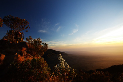
Approaching Mount Talang, the landscape shifts dramatically from lush tea plantations to dense tropical forest and then to stark volcanic terrain. The twin craters loom ahead, their steaming fumaroles hinting at the mountain’s restless power. The trail winds through vibrant birdlife and playful monkeys, contrasting with the barren, burnt trees near the summit. Reaching the crater rim, hikers are rewarded with panoramic views of volcanic lakes and the surrounding Sumatran highlands, a humbling encounter with Earth’s raw geological forces.
Mount Talang: Geological Background
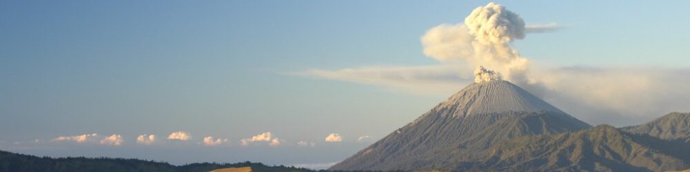
Mount Talang is an active stratovolcano formed by layers of hardened lava and volcanic ash. Its twin craters, a rare feature, host two crater lakes formed by volcanic activity. The volcano’s eruptions, recorded since the 19th century, have shaped the surrounding landscape with lava flows and ash deposits. Sulfur fumaroles and steam vents near the summit release volcanic gases, creating a dynamic environment. Unique minerals and endemic plants like the pitcher plant Nepenthes talangensis thrive here, making Talang a fascinating geological and ecological site.
Terrain and Hiking Experience on Mount Talang
The trek begins through cultivated farmland and tea plantations before entering dense jungle with slippery mud and occasional leeches. As elevation increases, the forest thins, revealing volcanic ash slopes and rocky ridges. Hikers navigate loose pumice and volcanic scree, requiring steady footing. The trail’s moderate steepness and humid tropical climate challenge endurance, while the presence of fumaroles near the summit adds an otherworldly atmosphere. The varied terrain demands good hiking boots and careful pacing.
What Makes Mount Talang Trek Unique
Mount Talang’s twin craters set it apart from many volcano treks. The presence of hot springs near the summit offers a rare geothermal feature accessible to trekkers. The trail’s proximity to vibrant tea plantations and local villages adds cultural depth. The mountain’s rich biodiversity, including endemic pitcher plants and abundant birdlife, enhances the natural appeal. Post-eruption burnt forests create a haunting yet beautiful landscape, making the trek a blend of adventure, geology, and ecology.
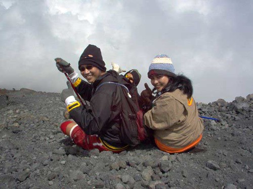
Summit and Crater Experience
Reaching Mount Talang’s summit, hikers encounter steaming fumaroles emitting sulfurous gases, their pungent scent filling the crisp mountain air. The twin crater lakes glisten below, framed by rugged volcanic ridges. The summit offers sweeping views over West Sumatra’s volcanic peaks and verdant valleys. The heat radiating from fumaroles contrasts with cool summit winds, while the sound of escaping gases punctuates the silence. This sensory experience connects trekkers intimately with the volcano’s living energy.
Best Time to Trek Mount Talang
The optimal trekking season is during the dry months from May to September, when trails are less muddy and weather conditions are stable. Avoid the monsoon season (October to April) due to heavy rains and slippery terrain. Volcanic activity is monitored regularly; trekkers should check for any alerts or restrictions before planning. Early morning starts are recommended to avoid afternoon heat and to catch clear summit views. Seasonal hazards include leeches in the jungle and occasional strong winds near the crater.
Trekking Routes and Trail Options
Two main routes lead to Mount Talang’s summit. The popular southern approach starts at Air Batumbuk (1,465 m), passing through Pesanggrahan camp (1,510 m) and a higher camp at 2,195 m near fumaroles. This route is well-marked and frequented by local hikers. The less-traveled northern route begins at Batu Bajanjang village (1,371 m), offering a more rugged path through farmland and forest with rich wildlife sightings. Both routes involve approximately 1,100 m altitude gain and take 5 to 7 hours to summit, with options for guided or self-guided treks.
Difficulty Assessment
Mount Talang is classified as a moderate volcano trek. The trail’s steep sections, slippery mud, and loose volcanic scree require good physical fitness and sure-footedness. Altitude effects are mild but noticeable near the summit. No technical climbing skills are needed, but hikers should be prepared for tropical humidity and variable weather. This trek suits experienced hikers comfortable with jungle terrain and volcanic environments, but beginners with good fitness can also attempt it with proper preparation.
Essential Volcano Trekking Gear
Key gear includes sturdy hiking boots with excellent grip for volcanic ash and mud, trekking poles for stability, and gaiters to protect against ash and leeches. A windproof and waterproof jacket is essential for summit winds and rain. Carry a headlamp for early starts, a hydration system to stay well-watered, and sun protection such as a hat and sunscreen due to limited shade. A gas mask or respirator is recommended if sulfur fumes intensify near fumaroles. Lightweight camping gear is needed for overnight stays at designated camps.
Safety and Volcanic Hazards
Mount Talang’s active status means hikers must remain vigilant. Volcanic gases like sulfur dioxide can cause respiratory irritation; avoid prolonged exposure near fumaroles. Crater edges may be unstable, and loose rocks pose fall risks. Sudden weather changes can reduce visibility and increase hypothermia risk. Always check updates from local volcanology offices and adhere to park regulations. Carry a first aid kit and inform guides or rangers of your itinerary. Emergency evacuation plans exist but can be challenging due to terrain.
Permits, Guides, and Logistics
A local permit is required to trek Mount Talang, obtainable at the registration office near the trailhead. Hiring a local guide is highly recommended for safety, navigation, and cultural insight. Guides can also assist with permits and campsite arrangements. The trailhead is accessible by vehicle up to a point, with motorbike taxis (ojeks) available for the final approach. Registration can be done online or in person. Seasonal closures may apply during heightened volcanic activity or heavy rains.
Where to Stay Near Mount Talang
Accommodation options include guesthouses and hotels in nearby towns such as Solok and Padang, approximately 40 km away. Trekking lodges and eco-camps near Air Batumbuk provide convenient access to the trailhead. Many hikers camp at designated spots on the mountain, including Pesanggrahan and the higher fumarole camp. Booking local homestays offers cultural immersion and support for communities. Early reservations are advised during peak trekking seasons.