Mount Bromo Volcano Trekking Guide: Exploring Java’s Iconic Active Stratovolcano
Mount Bromo, an active stratovolcano in East Java, Indonesia, offers an accessible yet dramatic volcano trekking experience. Known for its vast sea of volcanic sand and stunning sunrise views, this trek combines geological wonder with cultural richness. This guide covers the volcano’s geology, trekking routes, safety tips, and practical logistics for adventurers seeking to explore Bromo’s smoking crater and surrounding landscapes.
Quick Volcano Snapshot
| Volcano type | Stratovolcano |
|---|---|
| Elevation | 2,329 meters (7,641 feet) |
| Location | East Java, Indonesia |
| Activity status | Active |
| Trekking difficulty | Easy |
| Typical trek duration | 1-3 hours (crater hike and viewpoints) |
| Altitude gain | Approx. 200-300 meters from sea of sand to crater rim |
| Terrain type | Volcanic sand sea, ash slopes, concrete stairway |
| Best season | April to October (dry season) |
| Temperature range | 5°C to 20°C (41°F to 68°F) depending on time and altitude |
| Permit requirement | Park entrance fee required |
The Experience of Hiking Mount Bromo
Approaching Mount Bromo is like stepping into a surreal volcanic desert framed by towering peaks. The vast sea of fine volcanic sand stretches endlessly, contrasting sharply with the smoking crater that commands the horizon. The air carries the sharp scent of sulfur, and the ground vibrates faintly with the volcano’s restless energy. Hiking here is an intimate encounter with Earth’s raw power, where barren ash slopes give way to panoramic views of the Tengger caldera. Reaching the crater rim, the sight of swirling smoke and glowing vents evokes a profound sense of awe and adventure.
Mount Bromo: Geological Background
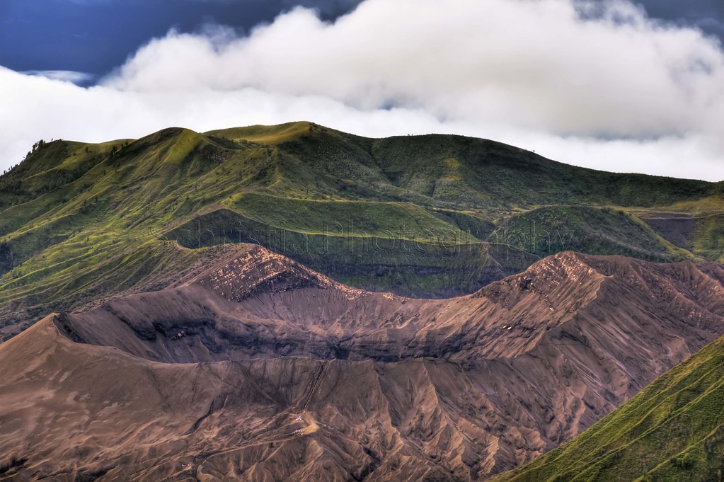
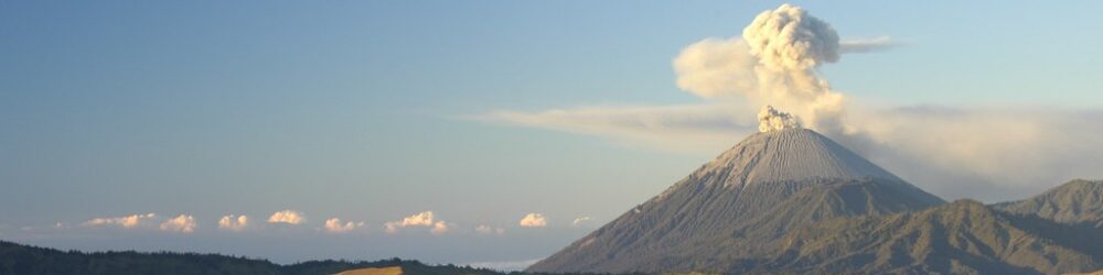
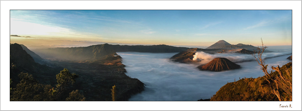
Mount Bromo is a classic stratovolcano formed by layers of hardened lava, ash, and volcanic debris. It sits within the massive Tengger caldera, a 10-kilometer-wide depression created by ancient eruptions. Bromo’s active crater emits continuous plumes of steam and sulfur gases, a sign of its persistent volcanic activity. The volcano’s last significant eruptions have shaped the surrounding sea of sand, a vast plain of volcanic ash and fine particles. Visitors can observe fumaroles and sulfur deposits near the crater, revealing ongoing subterranean processes. The landscape is a dynamic canvas of volcanic minerals and rugged formations.
Terrain and Hiking Experience on Mount Bromo
The trek begins with a descent from the village of Cemoro Lawang into the sea of sand, a flat expanse of volcanic ash that feels like walking on a lunar surface. Crossing this desert-like terrain takes about 20 to 30 minutes. The final ascent to the crater rim involves climbing approximately 240 concrete steps, a steep but manageable climb. The volcanic sand can be loose and shifting, requiring steady footing. Winds near the summit can be brisk, and temperatures drop significantly before sunrise. The combination of ash plains and stairway ascent makes the hike accessible yet physically engaging.

What Makes the Mount Bromo Trek Unique
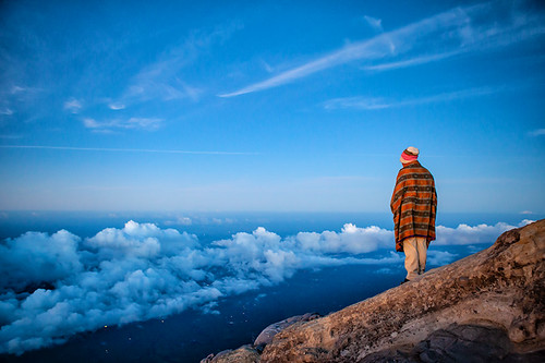
Mount Bromo’s trek is distinguished by its surreal sea of volcanic sand, which creates a dramatic foreground for the smoking crater. Unlike many volcanoes, Bromo’s crater is easily accessible, allowing hikers to peer directly into an active vent. The sunrise views from nearby viewpoints bathe the caldera in golden light, revealing a panorama of multiple volcanoes including Mount Semeru. The cultural presence of the Tenggerese people and their Hindu traditions add a rich human dimension. The combination of geological spectacle, cultural heritage, and ease of access makes Bromo a singular volcano trekking destination.
The Summit and Crater Experience
Reaching the crater rim is a sensory climax. The sulfurous smell is pungent and unmistakable, while the ground beneath radiates warmth from fumaroles. Steam vents hiss and crackle, punctuating the silence with natural sounds of volcanic activity. Looking into the crater, hikers witness swirling smoke and occasional bursts of ash, a vivid reminder of the volcano’s living nature. The panoramic views extend across the Tengger caldera, with neighboring peaks and the vast sea of sand below. This moment blends exhilaration with reverence for the planet’s fiery heart.
Best Time to Trek Mount Bromo
The optimal trekking season is during the dry months from April to October, when clear skies enhance sunrise views and trails are less slippery. Early mornings are cold, often near freezing, so warm clothing is essential. Avoid the rainy season (November to March) due to slippery ash and limited visibility. Volcanic activity is continuously monitored; hikers should check for any alerts or restrictions before planning their trip. Sunrise treks are popular for spectacular light but require early starts and headlamps. Daytime climbs offer warmer temperatures and fewer crowds.
Trekking Routes and Trail Options
The primary route starts from Cemoro Lawang village, descending to the sea of sand before ascending the crater steps. This route takes about 1 to 1.5 hours round trip. Visitors can opt for a horse ride across the sand to shorten the trek. For sunrise views, many take a jeep to the Penanjakan viewpoint, followed by a short hike to the crater. Alternative trails include paths around the crater rim for more adventurous hikers willing to explore beyond the main staircase. Guided tours are widely available, but independent trekking is feasible with proper preparation.

Difficulty Assessment
Mount Bromo is classified as an easy volcano trek suitable for most healthy travelers. The terrain is mostly flat volcanic sand with a short steep climb via concrete stairs. No technical climbing skills are required. Altitude is moderate at around 2,300 meters, with minimal risk of altitude sickness. Fitness level should be moderate to handle the uphill climb and walking on loose sand. The trek is accessible to beginners but can be physically demanding if done rapidly or in cold conditions.
Essential Volcano Trekking Gear
Key gear includes sturdy hiking boots with good grip for sandy and rocky terrain, warm layered clothing for cold pre-dawn temperatures, and a windproof jacket. Trekking poles can aid balance on loose sand. A headlamp is essential for early morning starts. Sun protection such as sunglasses, sunscreen, and a hat is important due to high UV exposure and lack of shade. Carry sufficient water and snacks. A gas mask or respirator is generally not required but may be useful for sensitive individuals due to sulfur fumes.
Safety and Volcanic Hazards
While Mount Bromo is active, eruptions are typically mild and monitored by Indonesian authorities. Hazards include exposure to sulfur gases, which can irritate eyes and lungs. Stay on marked trails to avoid unstable crater edges and loose volcanic scree. Falling rocks are rare but possible near the crater rim. Weather can change rapidly, bringing cold winds and reduced visibility. Always heed official warnings and park regulations. Use local guides if unfamiliar with the area for enhanced safety.
Permits, Guides, and Logistics
Visitors must pay a park entrance fee at Bromo Tengger Semeru National Park. Guides are not mandatory but recommended for safety and cultural insight. Organized jeep tours are popular for sunrise viewing and crater access. Independent trekking is possible from Cemoro Lawang village, where accommodation and services are available. The nearest airports are in Surabaya and Malang, with road transfers taking 3-4 hours. Advance planning is advised during peak seasons to secure lodging and transport.
Where to Stay Near Mount Bromo
The village of Cemoro Lawang is the primary base for Bromo treks, offering guesthouses, lodges, and small hotels with views of the caldera. Accommodations range from budget hostels to mid-range inns. Nearby towns such as Probolinggo and Malang provide additional lodging options but require longer transfers. Staying in Cemoro Lawang allows easy access to early morning jeep tours and trekking routes. Some eco-lodges and homestays offer cultural experiences with the Tenggerese community.