Climbing Mount Shasta: The Definitive Technical Volcano Trekking Guide to California’s Glaciated Stratovolcano
Mount Shasta, a towering dormant stratovolcano in Northern California, offers a demanding and technical trekking experience. This guide covers its unique glacial features, geological background, detailed route options, permit requirements, safety considerations, and seasonal strategies for climbers seeking an alpine adventure on one of North America's most iconic volcanic peaks.
Quick Volcano Snapshot
| Volcano type | Stratovolcano |
|---|---|
| Elevation | 14,179 ft (4,322 m) |
| Location | Siskiyou County, Northern California, United States |
| Activity status | Dormant |
| Trekking difficulty | Demanding to Technical mountaineering |
| Typical trek duration | 1 to 3 days depending on route and acclimatization |
| Altitude gain | Approximately 7,000 ft (2,130 m) from trailheads |
| Terrain type | Volcanic rock, ash slopes, glaciers, snowfields, scree |
| Best season | Late May to early July |
| Temperature range | Summer highs 40°F to 70°F; summit temps can drop below freezing |
| Permit requirement | Wilderness Permit and Summit Pass required |
The Experience of Hiking Mount Shasta
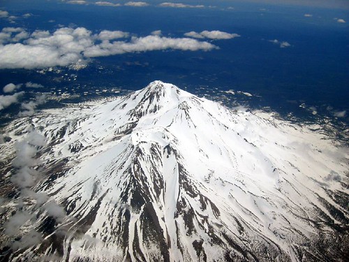
Approaching Mount Shasta, the landscape shifts dramatically from dense conifer forests to stark volcanic slopes crowned with glaciers. The mountain’s massive, conical silhouette dominates the horizon, evoking a sense of ancient power and geological grandeur. As you ascend, the terrain becomes a mosaic of loose volcanic scree, hardened lava flows, and glacial ice, contrasting sharply with the lush valleys below. Reaching the summit crater, the air thins and the panorama unfolds—vast wilderness stretching for miles, punctuated by rugged peaks and shimmering snowfields. The emotional surge of standing atop this dormant giant is profound, a moment where the Earth’s fiery past meets the climber’s triumph.
Mount Shasta: Geological Background
Mount Shasta is a classic stratovolcano formed by successive layers of lava, ash, and volcanic debris. Rising abruptly at the southern end of the Cascade Range, it is one of the tallest peaks in the region. Its formation began hundreds of thousands of years ago through repeated eruptions that built its broad base and steep summit cone. The volcano features multiple satellite cones, including Shastina, and is sculpted by glaciers that carve deep crevasses and icefalls into its flanks. Fumaroles and steam vents mark residual volcanic activity, while sulfur deposits and volcanic minerals pepper the terrain. The mountain’s geology tells a story of fire and ice, with lava flows interspersed by glacial erosion shaping its dramatic profile.
Terrain and Hiking Experience on Mount Shasta
The trek up Mount Shasta challenges hikers with a variety of terrain types. Lower slopes wind through dense forests and alpine meadows, transitioning to loose volcanic talus and scree fields higher up. Ash slopes demand careful footing, while sections of lava rock require scrambling skills. Above 10,000 feet, glaciers and snowfields dominate, necessitating crampons and ice axes. Exposure on ridges and near the crater rim can be intense, with strong winds and rapidly changing weather. Altitude effects become pronounced, requiring acclimatization and steady pacing. The terrain’s diversity shapes the climb’s difficulty, blending technical mountaineering with demanding endurance.

What Makes Mount Shasta Trek Unique
Mount Shasta’s unique blend of volcanic and glacial features sets it apart. It is one of the few stratovolcanoes in the Cascade Range crowned year-round by glaciers, offering climbers a rare alpine volcano experience. The vast snowfields and crevassed glaciers contrast with volcanic ash deserts and rugged lava flows. The mountain’s solitary prominence creates its own weather patterns, often producing lenticular clouds and sudden storms. Its spiritual significance and dramatic summit views add to the allure. This combination of geological complexity, technical challenge, and natural beauty makes Mount Shasta a standout volcano trek.
Summit and Crater Experience on Mount Shasta
Reaching Mount Shasta’s summit is a sensory climax. The thin air carries the faint scent of sulfur from fumaroles, while the ground beneath radiates residual warmth. The crater rim offers sweeping views across the Cascade Range and beyond, with glaciers glinting in the sunlight. The sound of escaping volcanic gases mingles with the whisper of alpine winds. Climbers often pause to absorb the vastness, the silence punctuated only by the crunch of snow or shifting rocks. This moment embodies the mountain’s dormant power and the climber’s hard-earned achievement.

Best Time to Trek Mount Shasta
The optimal climbing season runs from late May through early July. During this window, snowpack is consolidated, making glacier travel safer and more efficient. Weather tends to be more stable, though afternoon storms can still develop rapidly. Later summer climbs expose hikers to loose scree and increased rockfall hazards as snow melts. Winter ascents are highly technical and dangerous due to extreme cold, avalanches, and ice. Early season climbs require crampons, ice axes, and avalanche awareness. Monitoring weather and avalanche forecasts is essential for safety.
Mount Shasta Trekking Routes and Trail Options
Popular routes include Avalanche Gulch, the standard and most accessible path, starting at Bunny Flat with about 7,000 feet of elevation gain. It requires crampons and ice axe use but is suitable for experienced hikers new to technical mountaineering. The Clear Creek Route offers a longer, less steep alternative with more loose rock and scree, favored in late summer when snow is minimal. Casaval Ridge and Hotlum Glacier routes cater to advanced climbers seeking technical challenges. Guided and self-guided options exist, with permits required for all routes above 10,000 feet.
Difficulty Assessment of Mount Shasta Trek
Mount Shasta is classified between demanding volcano ascent and technical mountaineering. The climb demands high fitness, glacier travel skills, and experience with crampons and ice axes. Altitude sickness is a risk above 8,000 feet, requiring acclimatization. Rockfall hazards and unstable scree increase technical difficulty. While the standard route avoids technical rock climbing, it requires careful route-finding and self-arrest proficiency. This trek is not suitable for beginners without mountaineering training or guided support.
Essential Volcano Trekking Gear for Mount Shasta
Key gear includes mountaineering boots compatible with crampons, ice axe, helmet, and crampons for glacier travel. Trekking poles and volcanic ash gaiters improve stability on loose terrain. A windproof and insulated jacket is vital for summit conditions. Headlamps are necessary for early starts. Gas masks are generally not required but carrying a respirator can help in rare fumarole areas. Hydration systems and sun protection are critical due to high altitude and exposed terrain. Pack out human waste bags are mandatory.
Safety and Volcanic Hazards on Mount Shasta
Though dormant, Mount Shasta poses hazards including sudden weather changes, avalanches in spring, rockfall, and altitude sickness. Crevasses on glaciers require vigilance. Wearing helmets reduces rockfall injury risk. Climbers must monitor volcanic activity alerts and weather forecasts. Permits help rangers track climbers for safety. Packing out all waste preserves the fragile alpine environment. Emergency shelters and GPS devices are recommended. Respecting wilderness regulations ensures a safer experience.
Permits, Guides, and Logistics for Mount Shasta
Climbers must obtain a free Wilderness Permit for entry and a $25 Summit Pass for climbs above 10,000 feet. Permits are available at ranger stations, trailheads, and local outfitters. Group sizes are limited to 10 to reduce impact. Guided climbs simplify permit acquisition and enhance safety. Camping is limited to seven nights per 30 days. Human waste must be packed out using provided bags. Planning logistics includes checking weather, avalanche conditions, and route status before departure.
Where to Stay Near Mount Shasta
Accommodations range from lodges and hotels in Mount Shasta City to campgrounds near trailheads like Bunny Flat. Eco camps and mountain hostels offer rustic options closer to the wilderness. Many climbers base themselves in town for supplies and acclimatization before heading to the mountain. Reservations are recommended during peak season. Local outfitters provide gear rentals and guided services. Staying near trailheads reduces approach time and allows early summit starts.
