Santorini Caldera Rim Trail: The Ultimate Volcano Trekking Guide to Greece’s Iconic Volcanic Landscape
Explore the Santorini Caldera Rim Trail, a spectacular 10 km hike along the edge of one of the world’s most dramatic submerged volcanic calderas. This easy trek offers breathtaking views of the Aegean Sea, volcanic islands, and whitewashed Cycladic villages. Discover the geology, terrain, routes, and practical tips for hiking this dormant caldera volcano in the Cyclades, Greece.
Quick Volcano Snapshot
| Volcano type | Caldera |
|---|---|
| Elevation | 340 meters (highest point on trail) |
| Location | Santorini, Cyclades, Greece |
| Activity status | Dormant |
| Trekking difficulty | Easy |
| Typical trek duration | 3 to 5 hours |
| Altitude gain | Approx. 500 meters cumulative ascent |
| Terrain type | Paved paths, rocky trails, volcanic scree |
| Best season | Spring to early autumn (April to October) |
| Temperature range | 15°C to 30°C (59°F to 86°F) |
| Permit requirement | No permit required |
The Experience of Hiking Santorini’s Caldera Rim
Walking the Santorini Caldera Rim Trail is a journey through a landscape shaped by immense volcanic forces. The trail clings to cliffs towering 300 meters above the Aegean Sea, offering panoramic views of the submerged caldera and volcanic islands at its center. The contrast between the stark volcanic rock and the vibrant whitewashed villages creates a dramatic visual spectacle. Each step reveals layers of geological history beneath your feet, while the salty sea breeze and endless horizon evoke a profound connection to the earth’s power. Reaching the trail’s end in Oia, with its iconic blue domes and sunset vistas, rewards hikers with a sense of accomplishment and awe.
Santorini Caldera: Geological Origins and Features
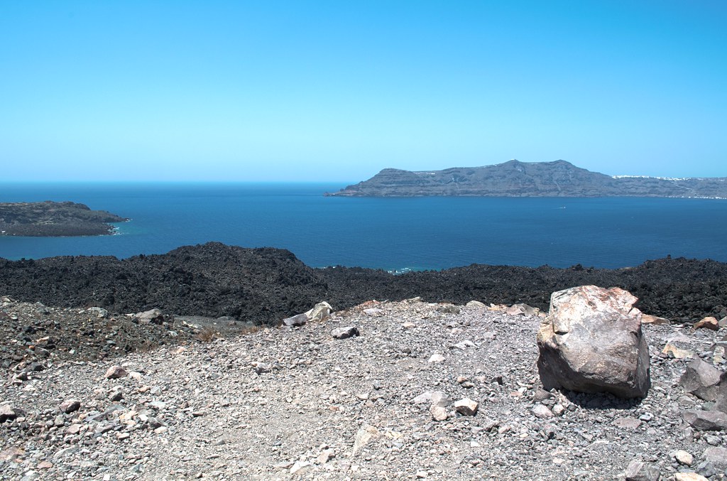
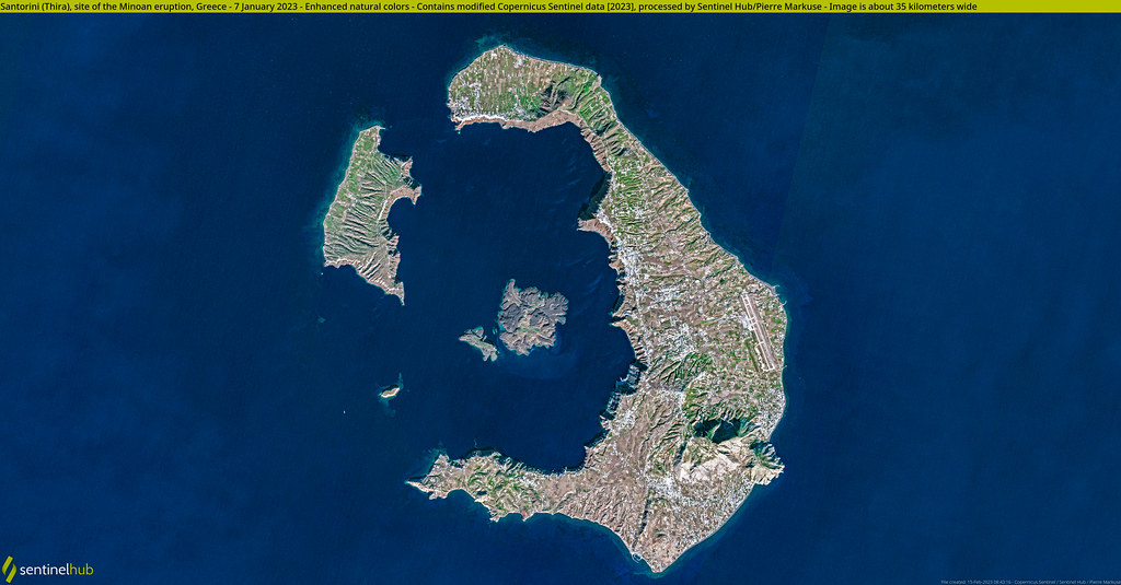
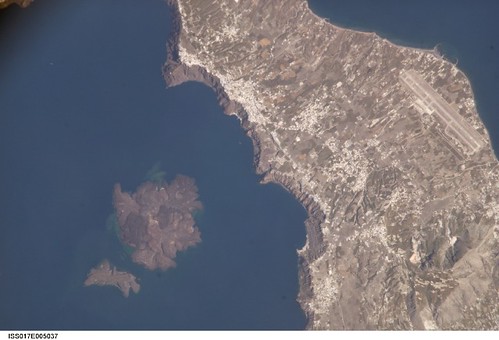
Santorini is a large, mostly submerged caldera formed by a series of massive volcanic eruptions, the most famous being the Minoan eruption around 1600 BCE. This cataclysmic event collapsed the volcano’s center, creating the flooded caldera visible today. The island group includes Santorini’s main island, Therasia, and the volcanic Kameni islands at the caldera’s center, formed by more recent lava flows. The caldera’s steep cliffs expose layers of pumice, ash, and hardened lava, while fumaroles and sulfur deposits mark the volcanic activity beneath. The geology tells a story of repeated eruptions, island reshaping, and ongoing tectonic subduction beneath the Aegean Sea.
Terrain and Hiking Experience on the Caldera Rim Trail
The trail combines paved pedestrian streets through villages with rocky, uneven volcanic paths along exposed ridges. Hikers encounter cobblestone lanes, loose volcanic scree, and occasional steep ascents and descents. The terrain demands sturdy footwear and careful footing, especially on rocky sections. The trail is mostly exposed with no shade, so sun protection and hydration are essential. The elevation gain is moderate but cumulative, with the highest point near Imerovigli at about 340 meters. The steady sea breeze often cools the air but can increase wind exposure near cliff edges.
What Makes the Santorini Caldera Trek Unique
This trek is unique for its combination of volcanic geology and iconic Cycladic culture. Few volcano hikes offer the chance to walk along a caldera rim with villages perched dramatically on cliffs above a submerged volcanic crater. The trail’s views of the central Kameni volcanic islands, the deep blue Aegean Sea, and the layered volcanic deposits are unparalleled. The cultural elements—whitewashed homes carved into volcanic rock, blue-domed churches, and ancient chapels—add a human story to the volcanic landscape. The trail’s accessibility and moderate difficulty make it a rare volcano trek suitable for casual hikers seeking geological wonder and scenic beauty.
Reaching the Summit and Experiencing the Caldera
While the trail does not lead to an active crater rim, the highest points near Imerovigli offer commanding views over the caldera’s flooded crater and volcanic islands. From here, hikers witness the vast scale of the collapsed volcano, the jagged cliffs plunging into the sea, and the steam vents on Nea Kameni island. The air carries a faint scent of sulfur, and the sound of waves crashing below enhances the dramatic atmosphere. The interplay of light and shadow across the caldera at sunrise or sunset creates a sensory experience that connects hikers deeply to the volcanic origins of Santorini.
Best Time to Trek the Santorini Caldera Rim
The ideal trekking season spans from spring through early autumn (April to October), avoiding the intense summer midday heat. Early morning or late afternoon starts are recommended to enjoy cooler temperatures and softer light for photography. The trail is generally accessible year-round but can be windy, especially in spring. Rain is rare but possible in winter months, making the trail slippery. Volcanic activity is dormant, so no restrictions apply, but hikers should always check local weather and trail conditions before setting out.
Routes and Trail Options Along the Caldera Rim
The classic route runs approximately 10 kilometers from Fira to Oia, passing through Firostefani and Imerovigli villages. The trail is a mix of paved walkways and natural volcanic paths. Hikers can choose to start in Fira, the island’s capital, or in Imerovigli for a shorter trek. The path is linear, so many opt to hike one way and return by bus or taxi. Optional detours include a visit to Skaros Rock near Imerovigli, a volcanic promontory with ruins and panoramic views. Guided tours are available, offering historical insights and logistical support, but the trail is well-marked for self-guided hikers.
Difficulty Assessment of the Caldera Rim Trail
Classified as an easy to moderate volcano trek, the Caldera Rim Trail requires basic fitness and sure-footedness on uneven terrain. The elevation gain is moderate but cumulative, with some steep sections and rocky paths. No technical climbing skills are needed, making it accessible to most hikers with reasonable health. The main challenges are exposure to sun and wind, and the need for proper footwear due to loose volcanic scree and cobblestones. Overall, it is suitable for beginner to intermediate hikers seeking a scenic volcanic experience.
Essential Gear for Hiking Santorini’s Caldera Rim
Key gear includes sturdy hiking shoes or sneakers with good grip to handle rocky and uneven surfaces. Sun protection is critical: wide-brimmed hat, sunglasses, and high-SPF sunscreen. Carry at least 2 liters of water per person, as the trail is unshaded with no water sources. Lightweight, breathable clothing is recommended. Trekking poles can aid balance on steep or loose sections. A small backpack for snacks, camera, and a windproof jacket for cooler or windy conditions is advisable. A fully charged phone and a map or GPS app help with navigation.
Safety and Volcanic Hazards on the Caldera Rim Trail
Santorini’s volcano is dormant, so eruption risk is minimal for hikers. However, hazards include unstable cliff edges, loose scree, and sudden gusts of wind near exposed ridges. Hikers should stay on marked paths and avoid approaching cliff edges, especially in windy conditions. The trail’s exposure to sun and heat requires careful hydration and sun protection. There are no official monitoring stations on the trail, but local authorities provide updates if volcanic activity changes. Always check weather forecasts and trail conditions before hiking.
Permits, Guides, and Logistics for the Caldera Rim Trek
No permits or entrance fees are required to hike the Santorini Caldera Rim Trail. The trail is open year-round and unguided hiking is common. Guided tours are available and recommended for those interested in geological and cultural insights, as well as logistical convenience. Tours often include hotel pickup, snacks, and sunset viewing. Public buses connect Fira and Oia, facilitating one-way hikes. Hikers should plan return transport in advance, especially during peak tourist seasons. Respect local regulations and private property along the trail.
Where to Stay Near the Santorini Caldera Trail
Accommodation options abound in Fira, the island’s capital and trailhead, ranging from boutique hotels to guesthouses. Firostefani and Imerovigli offer quieter stays with stunning caldera views and easy trail access. Oia, the trail’s endpoint, is famous for luxury lodgings and sunset vistas. Eco camps and hostels are limited but available on the island. Staying near the trailheads allows early starts and late returns. Booking in advance is advised during high season. Many lodgings provide shuttle services or easy access to public transport.