Hiking Pacaya Volcano: The Ultimate Guide to Guatemala’s Active Lava Trek
Explore Pacaya Volcano, one of Guatemala’s most accessible and active volcanoes. This guide covers geology, trekking routes, safety, gear, and the unique thrill of witnessing volcanic landscapes and lava flows near Antigua.
Quick Volcano Snapshot
| Volcano type | Complex stratovolcano |
|---|---|
| Elevation | 2,552 meters (8,373 feet) |
| Location | Guatemala Highlands, Guatemala |
| Activity status | Active |
| Trekking difficulty | Moderate |
| Typical trek duration | 2 to 3 hours |
| Altitude gain | Approximately 457 meters (1,500 feet) |
| Terrain type | Volcanic rock, lava fields, ash slopes |
| Best season | Dry season (November to April) |
| Temperature range | 10°C to 25°C (50°F to 77°F) |
| Permit requirement | Guide required; park entrance fee applies |
The Thrill of Hiking Pacaya Volcano
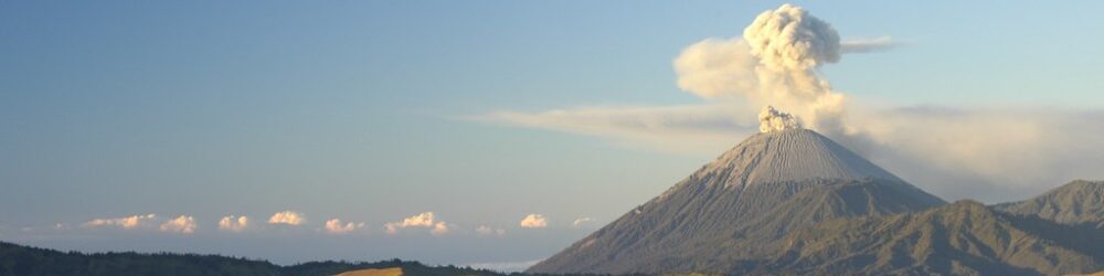
Approaching Pacaya Volcano, the landscape shifts dramatically from lush highland forests to stark black lava fields. The air carries a faint sulfur scent, hinting at the geological forces beneath your feet. As you ascend, the terrain becomes rugged with volcanic rocks and ash, a raw reminder of Earth’s fiery power. Reaching the upper slopes, the panorama unfolds—smoke plumes drift from fumaroles, and distant volcanoes punctuate the horizon. The emotional surge of standing near an active volcano’s crater, feeling the heat radiate from cooled lava flows, is an unforgettable encounter with nature’s primal energy.
Pacaya Volcano: A Dynamic Complex Stratovolcano
Pacaya is a complex stratovolcano formed about 23,000 years ago through successive eruptions layering lava, ash, and volcanic debris. Its steep slopes are shaped by frequent lava flows and ash deposits. Since 1565, Pacaya has erupted over 23 times, with ongoing activity since 1961. The volcano’s crater features fumaroles emitting steam and sulfur gases, while hardened lava fields create jagged terrain. These geological processes continuously reshape the landscape, offering hikers a living classroom of volcanic activity and mineral deposits.
Navigating Volcanic Terrain on the Pacaya Trek
The hike begins on cobblestone paths near San Francisco de Sales, quickly transitioning to steep dirt trails and rugged volcanic rock. Hikers encounter loose pumice, hardened lava fields, and occasional steam vents. The ascent challenges with a steady incline and altitude effects around 2,500 meters. Wind gusts near the summit add to the raw atmosphere. Descents require care on slippery scree and volcanic ash. The varied terrain demands good footwear and moderate fitness but rewards with surreal volcanic vistas.
Unique Features of the Pacaya Volcano Trek
Pacaya’s defining feature is its active status, allowing hikers to witness recent lava flows and steaming fumaroles up close. Unlike many volcanoes, visitors can roast marshmallows on the volcanic heat vents, a playful interaction with the landscape. The proximity to Antigua makes it accessible for day trips, while the volcanic desert terrain contrasts sharply with surrounding green highlands. The chance to see glowing lava during eruptions, though rare, adds an extraordinary dimension to this trek.
Reaching the Summit: Sensory Encounter with Volcanic Power
At the upper reaches, hikers stand near the crater rim surrounded by cooled lava fields. The sulfurous smell intensifies, mingling with the warmth radiating from fumaroles. Steam vents hiss softly, punctuating the silence with natural sounds. Views stretch across Guatemala’s volcanic highlands, with neighboring peaks like Agua and Fuego visible on clear days. The raw textures of black volcanic rock underfoot and the expansive sky above create a profound sense of connection to Earth’s fiery heart.
Optimal Seasons and Conditions for Trekking Pacaya
The dry season from November to April offers the best conditions for hiking Pacaya, with stable weather and clearer skies. The wet season brings slippery trails and reduced visibility. Volcanic activity can affect access; authorities monitor eruptions and may restrict summit approaches for safety. Early morning or late afternoon treks avoid midday heat and provide dramatic lighting for photography. Sunrise hikes offer cooler temperatures and the chance to witness volcanic glow if activity permits.
Trekking Routes and Trail Choices on Pacaya
Two main trails lead to Pacaya’s summit area, with the La Corona Trail being the most popular and shorter route. Starting near San Francisco de Sales, this circular trail covers about 5 kilometers with an elevation gain of 457 meters. Guided tours typically use this path, lasting 2 to 3 hours round-trip. Horseback options are available for less experienced hikers. Independent hiking is not permitted without a certified guide due to safety concerns and park regulations.
Assessing the Difficulty of the Pacaya Volcano Trek
Pacaya is classified as a moderate volcano trek. The terrain includes steep sections, loose volcanic rock, and ash slopes that require sure footing. Altitude near 2,500 meters can cause breathlessness for some. No technical climbing skills are needed, but a reasonable fitness level is essential. The trail is accessible to hikers with some experience, though frequent breaks are common. The presence of guides ensures safety and navigation through dynamic volcanic terrain.
Gear Essentials for Hiking Pacaya Volcano
Key gear includes sturdy hiking boots with excellent grip for volcanic rock and scree. Trekking poles aid balance on steep and loose terrain. A windproof jacket protects against gusts near the summit. Sun protection is critical due to minimal shade—hat, sunglasses, and sunscreen are recommended. Carry sufficient water and snacks. A headlamp is useful for early morning or sunset hikes. Gas masks or respirators are generally not required but check current volcanic activity advisories. Lightweight gloves can help when scrambling over rough lava.
Safety Considerations and Volcanic Hazards on Pacaya
Pacaya’s active status means hikers must be vigilant of volcanic gases, unstable crater edges, and sudden changes in activity. Falling rocks and loose scree pose risks on steep slopes. The park enforces mandatory guide accompaniment to mitigate hazards. Monitoring agencies track eruptions and issue warnings; hikers should heed all official advice. Weather can shift rapidly, increasing exposure risks. Emergency protocols and communication devices are recommended for guided groups.
Permits, Guide Requirements, and Trekking Logistics
Entry to Parque Nacional Volcán de Pacaya requires an entrance fee (approximately 100 quetzales). Certified guides are mandatory for all hikes, costing around 200 quetzales. No public transport reaches the park; private shuttles or tours from Antigua are common. Booking tours often includes transport, guide fees, and sometimes meals. Independent hiking without a guide is prohibited for safety. Seasonal closures may occur during heightened volcanic activity.
Accommodation Options Near Pacaya Volcano
Antigua Guatemala, about 1 to 1.5 hours away, serves as the primary base for Pacaya treks, offering a range of hostels, eco-lodges, and boutique hotels. Closer to the park entrance, small guesthouses and local accommodations exist but are limited. Some tours offer overnight camping near the volcano for sunrise experiences. Staying in Antigua provides access to transport, gear rental, and guided tour services, making it the preferred hub for volcano hikers.