Trekking Mount Sakurajima: Japan’s Most Active Volcano Adventure Guide
Mount Sakurajima, an iconic active stratovolcano in Kyushu, Japan, offers an accessible yet thrilling volcano trekking experience. This guide covers its geology, hiking terrain, safety tips, routes, and cultural highlights, helping adventurers explore its dynamic volcanic landscape safely and memorably.
Quick Volcano Snapshot
| Volcano type | Stratovolcano |
|---|---|
| Elevation | 1117 m |
| Location | Kagoshima, Kyushu, Japan |
| Activity status | Active |
| Trekking difficulty | Easy to Moderate |
| Typical trek duration | 3 to 6 hours depending on route |
| Altitude gain | Up to 400 m on main hiking routes |
| Terrain type | Lava fields, paved roads, volcanic ash slopes |
| Best season | May to October |
| Temperature range | 15°C to 30°C (seasonal) |
| Permit requirement | No permit required |
The Experience of Hiking Mount Sakurajima
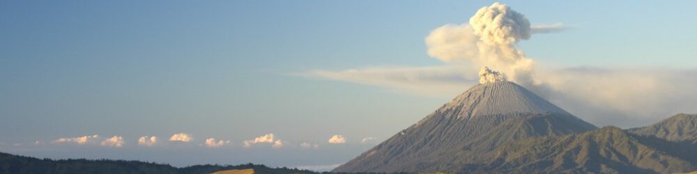
Approaching Mount Sakurajima, the air thickens with the scent of sulfur and the landscape unfolds in stark contrasts. Jagged lava fields meet lush orchards, while plumes of smoke rise steadily from the crater, a reminder of the volcano’s restless heart. Hiking here means walking alongside a living force of nature, where every step reveals the raw power shaping the island. The journey culminates in panoramic views of Kagoshima Bay and the smoking summit, an emotional encounter with Earth’s fiery core.

Geological Background of Mount Sakurajima
Mount Sakurajima is a classic stratovolcano formed by layers of hardened lava, ash, and volcanic rocks. It sits within the larger Aira caldera, a massive volcanic depression created by a colossal eruption over 22,000 years ago. Sakurajima’s frequent eruptions, some explosive, continuously reshape its summit and lava flows. The volcano’s fumaroles emit sulfurous gases, and its landscape is dotted with hardened lava fields from historic eruptions, notably the massive 1914 event that connected the island to Kyushu mainland. The volcanic minerals enrich the soil, supporting unique flora and agriculture.
Terrain and Hiking Experience on Sakurajima
Hiking Sakurajima is a blend of paved coastal roads, gentle ascents, and rugged lava fields. Trails are generally well-maintained but can be covered in volcanic ash, making footing slippery. The main ascent to Yunohira Observatory involves a steady climb of about 400 meters on paved roads with occasional volcanic rock underfoot. Wind near the summit can be strong and temperatures vary sharply between shaded valleys and exposed ridges. The terrain is less technical than many volcanoes, but hikers should be prepared for volcanic dust and uneven surfaces.
What Makes the Sakurajima Trek Unique
Sakurajima’s uniqueness lies in its status as one of the world’s most active volcanoes accessible to hikers. Frequent eruptions create a dynamic landscape where steaming vents and fresh lava flows coexist with cultivated mandarin orchards. The proximity to Kagoshima city and the short ferry crossing add cultural richness. Hikers witness volcanic activity safely from observation points, experience volcanic ash dusting the trails, and explore lava fields formed less than a century ago. The island’s volcanic soil supports rare agricultural products, blending natural power with human resilience.
The Summit and Crater Experience
While direct summit access is prohibited due to active eruptions, reaching viewpoints like Yunohira Observatory offers dramatic encounters with Sakurajima’s crater. From here, hikers see thick smoke plumes rising, hear the subtle hiss of escaping gases, and smell the unmistakable sulfur tang. The heat radiating from fumaroles contrasts with the cool sea breeze. The panoramic vista includes Kagoshima Bay, the city skyline, and the vast volcanic terrain, creating a sensory-rich moment that underscores the volcano’s living presence.

Best Time to Trek Mount Sakurajima
The ideal trekking season runs from late spring through early autumn (May to October), when weather is warm and trails are dry. Summers can be hot and humid, so early morning hikes are recommended. Winter months are cooler but less comfortable due to wind and rain. Volcanic activity is continuous, so always check current eruption alerts and weather conditions before trekking. Avoid days with heavy ashfall or strong winds for safety and visibility.
Trekking Routes and Trail Options
The most popular route is the hike to Yunohira Observatory, a 5 km round trip with 400 m elevation gain, starting from the ferry terminal area. This paved road trail offers safe access and spectacular views. The Nagisa Lava Trail along the coast provides an easy, flat walk through historic lava fields. For a longer circuit, the Sakurajima Island View Bus route can be combined with walking segments to explore multiple observation points. Guided tours are available, but self-guided hiking is common with good signage and maps.
Difficulty Assessment
Mount Sakurajima’s hikes range from easy to moderate difficulty. Trails are mostly paved or well-maintained, with gentle to moderate elevation gain. No technical climbing skills are required. Fitness levels should be moderate due to the uphill sections and exposure to volcanic ash and wind. The trek is suitable for adventurous beginners and intermediate hikers seeking a unique volcanic environment without extreme mountaineering challenges.
Essential Volcano Trekking Gear
Key gear includes sturdy hiking boots with good grip for ash and rocky terrain, trekking poles for stability on slopes, and a windproof jacket to protect against gusts near the summit. A hat and sunscreen are essential due to limited shade. Carry a scarf or mask to filter volcanic ash, especially on windy days. Hydration packs or water bottles are critical, as facilities are limited on trails. A headlamp is useful for early starts or late returns. Lightweight layers help adjust to temperature changes.
Safety and Volcanic Hazards
Sakurajima’s active status demands vigilance. Volcanic gases like sulfur dioxide can irritate eyes and lungs; wearing a mask is advised during ashfall. Crater areas are off-limits due to eruption risk and unstable ground. Falling rocks and sudden ash emissions can occur, so heed all warning signs and local advisories. Weather can change rapidly, increasing risk on exposed trails. The Japan Meteorological Agency monitors activity closely; always check their updates before hiking. Emergency shelters and evacuation routes are marked on the island.
Permits, Guides, and Logistics
No special permits are required for hiking Sakurajima. Entry to the island is free, but ferry tickets from Kagoshima Port cost about ¥200 round trip. Guided hikes are available and recommended for first-time visitors or those wanting detailed geological insights. The Sakurajima Island View Bus offers convenient transport between key points. Seasonal closures or restrictions may apply during heightened volcanic activity; always verify current conditions with local authorities or visitor centers.
Where to Stay Near Mount Sakurajima
Most visitors stay in Kagoshima city, which offers a range of accommodations from budget hostels to upscale hotels. The city is a 15-minute ferry ride from Sakurajima, making day trips easy. On the island, guesthouses and small inns provide a more immersive experience but are limited in number. Staying in Kagoshima also offers access to hot springs, local cuisine, and transport connections. Booking in advance is advised during peak seasons.